 |
Laneway Suites in the City of Toronto - 2018 A Laneway Suite is a
self-contained residential unit located on the same lot as a
detached house, semi-detached house, townhouse, or other
low-rise house. A Laneway Suite is typically located in the back
yard next to a public laneway and is generally smaller in size,
and completely detached from the main house on the lot.
Laneway Suites provide new rental housing opportunities
within established neighbourhoods, contributing to a wider range
of housing options.
Only properties next to a public lane allowed an additional
residential unit within an ancillary building, known as a
laneway suite. |
|
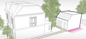
Garden Suites in the City of Toronto - February 2, 2022
A garden suite is a housing unit, usually located in the
backyard of an existing house, but separate and detached from
the main house. Garden suites, like laneway suites, are
generally smaller than the main house on the lot. Garden Suites
are often a way to create homes for family members – parents,
grandparents or adult children – or can be used as rental
housing units.
The Official Plan and Zoning Bylaw amendments for garden suites
allow for the construction of an additional residential unit on
residential properties that are not located on a public lane.
Video |
|
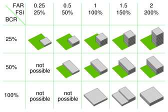
Floor
area ratio (FAR) Floor area ratio (FAR) is the
ratio of a building's total floor area (gross floor area) to the
size of the piece of land upon which it is built. It is often
used as one of the regulations in city planning along with the
building-to-land ratio.[1] The terms can also refer to limits
imposed on such a ratio through zoning.
Written as a formula, FAR = gross floor area / area of the
plot .
Lower maximum-allowed floor area ratios are linked to lower
land values and lower housing density
Floor Area ratio is sometimes called floor space
ratio (FSR), floor space index (FSI), site ratio or plot
ratio.
The difference between FAR and FSI is that the first is a
ratio, while the latter is an index. Index numbers are values
expressed as a percentage of a single base figure. Thus an FAR
of 1.5 is translated as an FSI of 150%.
|
 By
Cmglee - Own work, CC BY-SA 4.0,
https://commons.wikimedia.org/w/index.php?curid=82605669 By
Cmglee - Own work, CC BY-SA 4.0,
https://commons.wikimedia.org/w/index.php?curid=82605669
|
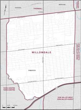
Willowdale (electoral district)
Willowdale consisted initially of the part of the
Borough of North York bounded on the north by the borough limit
(Steeles Avenue), on the West by the West Branch of the
Don River and Bathurst Street, on the south by Highway
401, and on the east by Bayview Avenue.
|
Population (2021)[1] |
118,218 |
|
Electors (2015) |
74,205 |
|
Area (km²)[2] |
21 |
|
Pop. density (per km²) |
5,629.4 |
|
 |
|
What is supportive housing (or housing with support services)
Supportive housing is a combination of deeply affordable
housing and on-site supports that enable people to live as
independently as possible. Supportive housing can help people
stabilize their lives, help them stay housed and positively
contribute to communities. |
Calendar
|